
Fail:Easter Island map-de.svg

Size of this PNG preview of this SVG file: 800 × 569 pixels. Other resolutions: 320 × 228 pixels | 640 × 455 pixels | 1,024 × 729 pixels | 1,280 × 911 pixels | 2,560 × 1,821 pixels | 1,750 × 1,245 pixels.
Bikpela piksa (SVG file, nominally 1,750 × 1,245 pixels, file size: 856 KB)
Liklik toksave bilong senis
| Description |
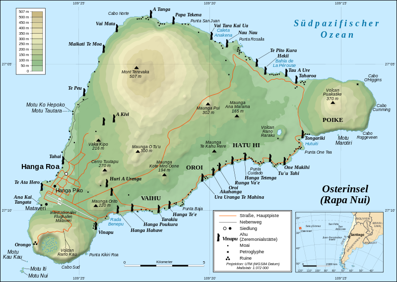
Deutsch: Topografische Karte der Osterinsel, deutsche Version
English: Detailed topographic map in German of Easter Island
Français : Carte topographique détaillée en allemand de l'île de Paques |
| Date | |
| Source |
Own work, translation of Image:Easter Island map-fr.svg Background and elevation reference maps: topographic map (IGM map ?) and CIA map Ahu names (ceremonial platforms with moai): prof. William Mulloy's map (easier to read here) and [1] Locator reference map: National Geographic |
| Author | Sting, translated by Titus Groan |
| Permission (Reusing this file) |
Creative Commons: share alike - attribution required |
| Other versions |
[]
|


![[1]](http://www.waymarker.co.uk/ml/rapanui/map.jpg)
This W3C-unspecified vector image was created with Inkscape .

|
This SVG file contains embedded text that can be translated into your language, using any capable SVG editor, text editor or the SVG Translate tool. For more information see: About translating SVG files. |
Laisens
I, the copyright holder of this work, hereby publish it under the following license:
This file is licensed under the Creative Commons Attribution-Share Alike 2.5 Generic license.
- You are free:
- to share – to copy, distribute and transmit the work
- to remix – to adapt the work
- Under the following conditions:
- attribution – You must give appropriate credit, provide a link to the license, and indicate if changes were made. You may do so in any reasonable manner, but not in any way that suggests the licensor endorses you or your use.
- share alike – If you remix, transform, or build upon the material, you must distribute your contributions under the same or compatible license as the original.
Ol senis bilong dispela fail
Click on a date/time to view the file as it appeared at that time.
| De/Taim | Liklik | Ol sais | Yusa | Tingting | |
|---|---|---|---|---|---|
| bilong nau | 16:31, 2 Oktoba 2012 | | 1,750 × 1,245 (856 KB) | NordNordWest | update |
| 17:24, 14 Me 2008 |  | 1,750 × 1,245 (536 KB) | NordNordWest | {{Assessments|com=1}} {{Information| |Description= {{de|Topografische Karte der Osterinsel, deutsche Version}} {{en|Detailed topographic map in German of Easter Island}} {{fr|Carte topographique détaillée en alle |
Ol fail link
Dispela pes i link long dispela fail:
Global file usage
The following other wikis use this file:
- Usage on als.wikipedia.org
- Usage on de.wikipedia.org
- Usage on de.wiktionary.org
- Usage on dsb.wikipedia.org
- Usage on hsb.wikipedia.org
- Usage on it.wiktionary.org
- Usage on mn.wikipedia.org