
Fail:Fiji (orthographic projection).svg

Size of this PNG preview of this SVG file: 550 × 550 pixels. Other resolutions: 240 × 240 pixels | 480 × 480 pixels | 768 × 768 pixels | 1,024 × 1,024 pixels | 2,048 × 2,048 pixels.
Bikpela piksa (SVG file, nominally 550 × 550 pixels, file size: 318 KB)
Liklik toksave bilong senis
| Description |
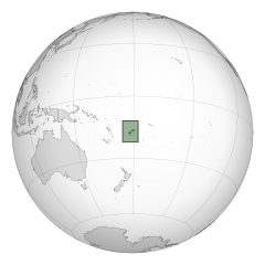
English: A map of the hemisphere centred on Fiji, using an orthographic projection, created using gringer's Perl script with Natural Earth Data (1:50000 resolution, simplified to 0.25px). Fiji is highlighted in green. |
| Date | |
| Source | Own work |
| Author | Gringer |
| SVG genesis |
.svg)
.svg)
.svg)
.svg)
.svg)
.svg)
.svg)
.svg)
.svg)
.svg)
.svg)
.svg)
.svg)
.svg)
.svg)
.svg)
.svg)
.svg)
.svg)
.svg)
.svg)
.svg)
.svg)
.svg)
.svg)
.svg)
.svg)
.svg)
.svg)
.svg)
.svg)
.svg)
.svg)
.svg)
.svg)
.svg)
.svg)
.svg)
.svg)
.svg)
.svg)
.svg)
.svg)
.svg)
.svg)
.svg)
.svg)
.svg)
.svg)
.svg)
.svg)
.svg)
.svg)
.svg)
.svg)
.svg)
.svg)
.svg)
.svg)
.svg)
.svg)
.svg)
.svg)
.svg)
.svg)
.svg)
.svg)
.svg)
.svg)
.svg)
.svg)
.svg)
.svg)
.svg)

.svg)

.svg)

.svg)
.svg)
.svg)
.svg)
.svg)
.svg)
.svg)


.svg)
.svg)
.svg)
.svg)
.svg)
.svg)
.svg)

.svg)
.svg)
.svg)
.svg)
.svg)
.svg)
.svg)
.svg)
.svg)

.svg)
.svg)
.svg)
.svg)
.svg)
.svg)
.svg)
_without_national_boundaries.svg)
.svg)
.svg)
.svg)
.svg)
.svg)
.svg)

.svg)
.svg)
.png)
.svg)
.svg)
.svg)
.svg)

.svg)
.svg)
.svg)
.svg)
.svg)
.svg)
.svg)
.svg)
.svg)
.svg)
.svg)

.svg)
.svg)
.svg)
.svg)
.svg)
.svg)
.svg)
.svg)
.svg)

.svg)
.svg)

.svg)
.svg)
.svg)
.svg)
.svg)
.svg)
.svg)
.svg)
.svg)
.svg)
.svg)
.svg)
.svg)
.svg)
.svg)
.svg)
.svg)
.svg)
.svg)
.svg)
.svg)
.svg)
.svg)
.svg)
.svg)
.svg)
.svg)
_-_Crimea_disputed.svg)
.svg)
.svg)
.svg)
.svg)
.svg)
.svg)
.svg)
.svg)
.svg)
.svg)
.svg)
_political.svg)
.svg)
.svg)
.svg)
.svg)
_-_Crimea_disputed_-_no_borders.svg)
.svg)
.svg)
.svg)
.svg)
.svg)
.svg)
.svg)
.svg)
.svg)
.svg)
.svg)

.svg)
.svg)
.svg)

.png)
.svg)
.svg)
.svg)
.svg)
.svg)
.svg)
.svg)
.svg)
.svg)
.svg)
.svg)
.svg)
.svg)
.svg)
.svg)
.svg)
.svg)
.svg)
.svg)
.svg)
.svg)
.svg)
.svg)
.svg)
.svg)
.svg)
.svg)
.svg)
.svg)
.svg)
.svg)
.svg)
.svg)
.svg)
.png)
.svg)
.svg)
.svg)
_(orthographic_projection).png)
.svg)
Ol senis bilong dispela fail
Click on a date/time to view the file as it appeared at that time.
| De/Taim | Liklik | Ol sais | Yusa | Tingting | |
|---|---|---|---|---|---|
| bilong nau | 23:31, 30 Ogas 2010 | | 550 × 550 (318 KB) | Gringer | Fiji highlighted by green box. |
| 23:25, 30 Ogas 2010 |  | 550 × 550 (274 KB) | Gringer | {{Information |Description={{en|1=A map of the hemisphere centred on Fiji, using an orthographic projection, created using gringer's Perl script with [http://www.naturalearthdata.com/ Natural Earth Data] (1:5 |
Ol fail link
Dispela pes i link long dispela fail:
Global file usage
The following other wikis use this file:
- Usage on ace.wikipedia.org
- Usage on af.wikipedia.org
- Usage on ar.wikipedia.org
- فيجي
- مستعمرة فيجي
- مستخدم:جار الله/قائمة صور مقالات العلاقات الثنائية
- العلاقات الأمريكية الفيجية
- العلاقات الأنغولية الفيجية
- العلاقات الفيجية الكورية الجنوبية
- العلاقات الإريترية الفيجية
- العلاقات السويسرية الفيجية
- العلاقات الألمانية الفيجية
- العلاقات الفيجية الليختنشتانية
- العلاقات البوليفية الفيجية
- العلاقات الفيجية الموزمبيقية
- العلاقات الألبانية الفيجية
- العلاقات البلجيكية الفيجية
- العلاقات الإثيوبية الفيجية
- العلاقات البيلاروسية الفيجية
- العلاقات الطاجيكستانية الفيجية
- العلاقات الروسية الفيجية
- العلاقات الرومانية الفيجية
- العلاقات الأرجنتينية الفيجية
- العلاقات الغامبية الفيجية
- العلاقات الفيجية القبرصية
- العلاقات السيراليونية الفيجية
- العلاقات الفيجية النيبالية
- العلاقات الفيجية الليبيرية
- العلاقات التشيكية الفيجية
- العلاقات الفيجية الميانمارية
- العلاقات الفيجية الكندية
- العلاقات السعودية الفيجية
- العلاقات الزيمبابوية الفيجية
- العلاقات الإسرائيلية الفيجية
- العلاقات البالاوية الفيجية
- العلاقات الفيجية المالية
- العلاقات الفيجية النيجيرية
- العلاقات اليمنية الفيجية
- العلاقات الفانواتية الفيجية
- العلاقات الغابونية الفيجية
- العلاقات البنمية الفيجية
- العلاقات الفيجية الكوبية
- العلاقات الجورجية الفيجية
- العلاقات التونسية الفيجية
- العلاقات الفيجية الكورية الشمالية
- العلاقات الهندية الفيجية
- العلاقات اليابانية الفيجية
- العلاقات الإيطالية الفيجية
- العلاقات الفيجية الناوروية
- العلاقات الأسترالية الفيجية
- العلاقات الزامبية الفيجية
View more global usage of this file.
.svg)
.svg)