Jump to content

Fail:Eyjafjallajökull.jpeg

Page contents not supported in other languages.
Long Wikipedia

Bikpela piksa (2,960 × 1,983 pixels, file size: 3.96 MB, MIME type: image/jpeg)

This file is from Wikimedia Commons and may be used by other projects. The description on its file description page there is shown below.

Description
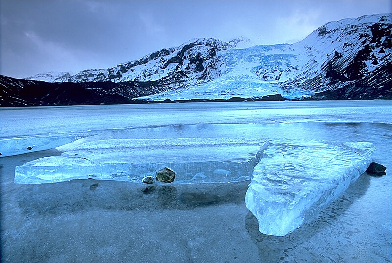
English: Gígjökull, an outlet glacier extending from Eyjafjallajökull, Iceland. Lónið is the lake visible in the foreground.
Tiếng Việt: Sông băng Eyjafjallajökull tại Iceland.

Photo was taken using the following technique:

  • Film: Fuji Velvia
  • Lens: 2.8/20
  • Filter: Gray progression
  • Body: Minolta Dynax 7
  • Support: Manfrotto 190B
Date 2003-02-13, 11:00–12:00
Source

Own work: http://fam-tille.de/sparetime.html

Author Andreas Tille
Permission
(Reusing this file)
Quote of http://fam-tille.de/island/winter/0213/2003_093.html - Permission is granted to copy, distribute and/or modify this images under the terms of the GNU Free Documentation License, Version 1.1 or any later version published by the Free Software Foundation.
I, the copyright holder of this work, hereby publish it under the following licenses:
GNU head Permission is granted to copy, distribute and/or modify this document under the terms of the GNU Free Documentation License, Version 1.2 or any later version published by the Free Software Foundation; with no Invariant Sections, no Front-Cover Texts, and no Back-Cover Texts. A copy of the license is included in the section entitled GNU Free Documentation License.
w:en:Creative Commons
attribution share alike
This file is licensed under the Creative Commons Attribution-Share Alike 3.0 Unported, 2.5 Generic, 2.0 Generic and 1.0 Generic license.
You are free:
  • to share – to copy, distribute and transmit the work
  • to remix – to adapt the work
Under the following conditions:
  • attribution – You must give appropriate credit, provide a link to the license, and indicate if changes were made. You may do so in any reasonable manner, but not in any way that suggests the licensor endorses you or your use.
  • share alike – If you remix, transform, or build upon the material, you must distribute your contributions under the same or compatible license as the original.
You may select the license of your choice.
Camera location63° 40′ 55″ N, 19° 38′ 00″ W  Heading=157.5° Kartographer map based on OpenStreetMap.View this and other nearby images on: OpenStreetMapinfo
Annotations
InfoField
This image is annotated: View the annotations at Commons

Assessment

Featured image

Wikimedia CommonsWikipedia

This is a featured picture on Wikimedia Commons (Featured pictures) and is considered one of the finest images. See its nomination here.

Wikipedia
 This is a featured picture on the English language Wikipedia (Featured pictures) and is considered one of the finest images. See its nomination here.
 This is a featured picture on the Persian language Wikipedia (نگاره‌های برگزیده) and is considered one of the finest images. See its nomination here.
 This is a featured picture on the Hebrew language Wikipedia (תמונות מומלצות) and is considered one of the finest images. See its nomination here.

If you have an image of similar quality that can be published under a suitable copyright license, be sure to upload it, tag it, and nominate it.

This image was selected as picture of the day on Vietnamese Wikipedia.

Captions

Add a one-line explanation of what this file represents

Items portrayed in this file

depicts Inglis

63°40'54.998"N, 19°37'59.999"W

heading Inglis: 157.5 degree

media type Inglis

image/jpeg

Ol senis bilong dispela fail

Click on a date/time to view the file as it appeared at that time.

De/TaimLiklikOl saisYusaTingting
bilong nau12:01, 2 Disemba 2004Thumbnail for version as of 12:01, 2 Disemba 20042,960 × 1,983 (3.96 MB)Ævar Arnfjörð Bjarmason

There are no pages that use this file.

Global file usage

The following other wikis use this file:

View more global usage of this file.