
Fail:Germany location map 23 April 1949 - 22 May 1949.svg

Bikpela piksa (SVG file, nominally 1,075 × 1,273 pixels, file size: 1.13 MB)
Liklik toksave bilong senis
| Description |
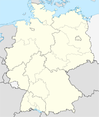
Deutsch: Positionskarte (West- und Mittel-) Deutschlands. Diese Karte zeigt den Gebietsstand zwischen 23. April_1949 bis 22. May 1949.
Quadratische Plattkarte, N-S-Streckung 150 %. Geographische Begrenzung der Karte:
English: Location map of Germany. Map shows Germany as of April 23rd 1949 till May 22nd 1949.
Equirectangular projection, N/S stretching 150 %. Geographic limits of the map:
|
||
| Date | Created in 2010 | ||
| Source |
own work, based on: |
||
| Author | TUBS | ||
| Permission (Reusing this file) |
I, the copyright holder of this work, hereby publish it under the following licenses:
This file is licensed under the Creative Commons Attribution-Share Alike 3.0 Unported license.
You may select the license of your choice. |
||
| Other versions |
Bundesrepublik Deutschland (vor 1990 nur West-Deutschland):
Deutsche Demokratische Republik (mit BRD im Ausschnitt):
Ostdeutschland (vor 1990 Deutsche Demokratische Republik):
Deutschland zwischen Mai 1945 und Oktober 1949:
Thematisch:
Deutsches Reich (1918–1945) (best used with this template (de)):
|


_23_May_1949_-_6_Oct_1949.svg)


_location_map.svg)
_location_map_2013.svg)


Ol senis bilong dispela fail
Click on a date/time to view the file as it appeared at that time.
| De/Taim | Liklik | Ol sais | Yusa | Tingting | |
|---|---|---|---|---|---|
| bilong nau | 07:30, 30 Epril 2010 | | 1,075 × 1,273 (1.13 MB) | TUBS | == {{int:filedesc}} == {{Information |Description= {{de|Positionskarte (West- und Mittel-) Deutschlands. Diese Karte zeigt den Gebietsstand zwischen 23. April_1949 bis 22. May 1949.}} Quadratische Plattkarte, N-S-Streckung 150 %. Geogr |
Ol fail link
There are no pages that use this file.
Global file usage
The following other wikis use this file:
- Usage on de.wikipedia.org
- Usage on en.wikipedia.org
- Usage on ru.wikipedia.org