
Fail:Deutschland Autobahnen.svg

Bikpela piksa (SVG file, nominally 1,073 × 1,272 pixels, file size: 467 KB)
Liklik toksave bilong senis
| Description |
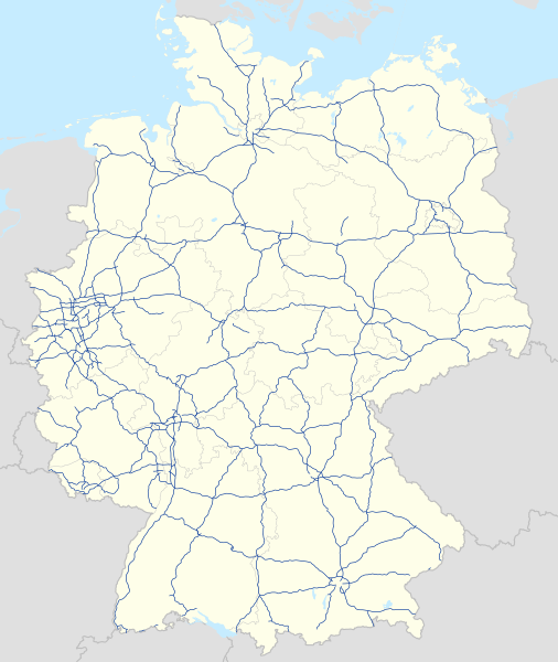
Deutsch: Karte der Autobahnen in Deutschland, Alternativkarte zu file:Germany location map.svg
|
||
| Date | |||
| Source | Own work | ||
| Author | NordNordWest | ||
| Permission (Reusing this file) |
This file is licensed under the Creative Commons Attribution-Share Alike 3.0 Germany license.
 This file is licensed under the Creative Commons Attribution-Share Alike 3.0 Unported license.
|
||
| Other versions |
Bundesrepublik Deutschland (vor 1990 nur West-Deutschland):
Deutsche Demokratische Republik (mit BRD im Ausschnitt):
Ostdeutschland (vor 1990 Deutsche Demokratische Republik):
Deutschland zwischen Mai 1945 und Oktober 1949:
Thematisch:
Deutsches Reich (1918–1945) (best used with this template (de)):
|
||
| SVG genesis | This map was created with unknown tool.
|


_23_May_1949_-_6_Oct_1949.svg)


_location_map.svg)
_location_map_2013.svg)


Ol senis bilong dispela fail
Click on a date/time to view the file as it appeared at that time.
| De/Taim | Liklik | Ol sais | Yusa | Tingting | |
|---|---|---|---|---|---|
| bilong nau | 13:19, 14 Disemba 2023 | | 1,073 × 1,272 (467 KB) | NordNordWest | upd |
| 16:23, 18 Julai 2023 |  | 1,073 × 1,272 (467 KB) | NordNordWest | upd | |
| 17:59, 1 Februeri 2023 |  | 1,073 × 1,272 (466 KB) | NordNordWest | upd | |
| 14:40, 18 Novemba 2019 |  | 1,073 × 1,272 (465 KB) | NordNordWest | upd | |
| 17:36, 27 Septemba 2019 |  | 1,073 × 1,272 (465 KB) | NordNordWest | upd | |
| 18:08, 5 Ogas 2019 |  | 1,073 × 1,272 (465 KB) | NordNordWest | upd | |
| 07:02, 14 Janueri 2019 |  | 1,073 × 1,272 (467 KB) | NJ Giggie | upd: A33 Teilstück freigegeben | |
| 18:26, 23 Disemba 2018 |  | 1,073 × 1,272 (466 KB) | NordNordWest | upd | |
| 11:22, 4 Septemba 2018 |  | 1,073 × 1,272 (466 KB) | NJ Giggie | corr: Autobahnenden der A61 gehen über die Kreuze Wanlo und Jackerath jeweils hinaus. Wiederherstellung des korrigierten Verlaufs der A448. | |
| 09:50, 2 Septemba 2018 |  | 1,073 × 1,272 (465 KB) | NordNordWest | upd |
Ol fail link
There are no pages that use this file.
Global file usage
The following other wikis use this file:
- Usage on de.wikipedia.org
- Usage on es.wikipedia.org
- Usage on fi.wikipedia.org
- Usage on gl.wikipedia.org
- Usage on it.wikipedia.org
- Usage on nl.wikipedia.org
- Usage on ro.wikipedia.org
- Usage on www.wikidata.org