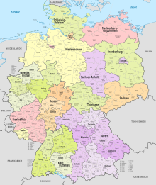
Fail:Germany (+districts) location map.svg
Appearance

Size of this PNG preview of this SVG file: 506 × 600 pixels. Other resolutions: 202 × 240 pixels | 405 × 480 pixels | 648 × 768 pixels | 864 × 1,024 pixels | 1,728 × 2,048 pixels | 1,073 × 1,272 pixels.
Bikpela piksa (SVG file, nominally 1,073 × 1,272 pixels, file size: 2.21 MB)
Ol senis bilong dispela fail
Click on a date/time to view the file as it appeared at that time.
| De/Taim | Liklik | Ol sais | Yusa | Tingting | |
|---|---|---|---|---|---|
| bilong nau | 12:40, 14 Me 2022 |  | 1,073 × 1,272 (2.21 MB) | TUBS | erlangen + höchstadt - double borders |
| 12:18, 14 Me 2022 |  | 1,073 × 1,272 (4.18 MB) | TUBS | Reverted to version as of 09:22, 14 February 2020 (UTC): reverted. Did more harm than good (esp. concering islands in the Baltic and North See) and double/ghost borders. Will deal with the Franconian issue later. | |
| 08:49, 7 Disemba 2021 |  | 1,073 × 1,272 (4.15 MB) | TUBS | erlangen + höchstadt vereint | |
| 09:22, 14 Februeri 2020 |  | 1,073 × 1,272 (4.18 MB) | TUBS | pushed LK Kehlheim to the right Bezirk. ((This is not an update. Some districts have merged by now, e.g. Göttignen/Osterode. Some borders have changed as of February 2020. Don't have the time to redraw the map.) | |
| 13:01, 29 Oktoba 2013 |  | 1,073 × 1,272 (3.17 MB) | TUBS | ||
| 12:52, 29 Oktoba 2013 |  | 1,073 × 1,272 (1.61 MB) | TUBS | real loc map | |
| 18:44, 28 Oktoba 2013 |  | 1,073 × 1,272 (5.82 MB) | TUBS | == {{int:filedesc}} == {{Information |Description={{de|Karte der politischen Gliederung Deutschlands in Länder, Regierungsbezirke, Landkreise und krsfr. Städte}} {{en|Map of administrative divisions of Germany. States, government districts, districts... |
Ol fail link
There are no pages that use this file.
Global file usage
The following other wikis use this file:
- Usage on de.wikipedia.org


